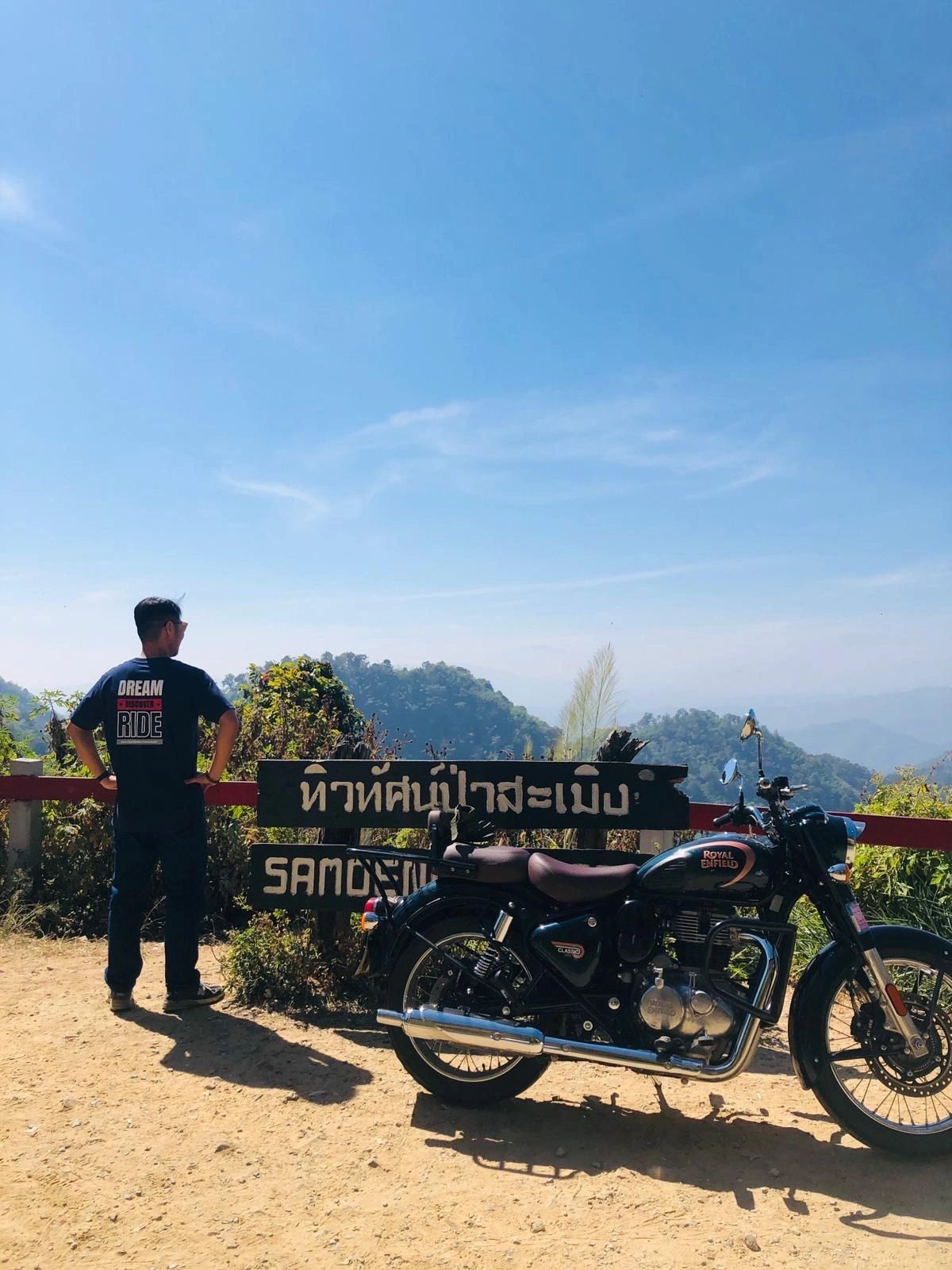
The short answer
The Samoeng Loop is a ~110 km sealed mountain circuit from Chiang Mai, on Routes 107, 1096, 1269 and 108. Two to two and a half hours of moving time, four to five realistic, a full day with stops. Best ridden November to February.
The tour that rides this road: Samoeng Loop (1 day) · or ask us on WhatsApp
THE LOOP AT A GLANCE
- Distance
- ~110 km door to door from the old city
- Riding time
- 2–2.5 hrs moving · 4–5 hrs realistic · a full day with stops
- High point
- ~1,100 m, on Route 1096 west of Mae Rim
- Total climbing
- ~1,500 m
- Roads
- 107 → 1096 → 1269 → 121 → 108, sealed the whole way
- Best months
- November to February
- Worst months
- March–April (haze). June–October is wet.
- Fuel
- Last branded station ~km 19; longest gap ~37 km
- Difficulty
- Gentle by mountain standards — not a first-ever ride
- Start by
- 08:00–09:00, and the day works
THE ROUTE, LEG BY LEG
The circuit runs north out of Chiang Mai on Route 107, turns west onto Route 1096 through Mae Rim and the Mae Sa valley, climbs over the ridge to Samoeng, then comes back on Route 1269 to Hang Dong and into town on Route 108. Four legs. No navigation problem worth worrying about — the turns are signposted and there is only one road.
| Leg | Road | Distance | Riding time |
|---|---|---|---|
| Chiang Mai old city → Mae Rim junction | 107 | 15.6 km | 20 min |
| Mae Rim junction → Samoeng town | 1096 | 35.5 km | 50 min |
| Samoeng → Hang Dong | 1269 → 121 | 43.6 km | 60 min |
| Hang Dong → Chiang Mai old city | 108 | 15.2 km | 20 min |
| Total | 109.8 km | ~2 hrs |
Those times are moving time on an empty road. Nobody rides it that way. Add fuel, coffee, photographs and one wrong turn, and four to five hours is the honest figure.
You will see “about 100 km” quoted almost everywhere. That measures from the edge of town rather than the moat. Both are right; ours is the one that matches your odometer if you start from the old city.
WHICH WAY ROUND?
Every guide has an opinion and they do not agree, so here is the actual trade-off instead of an instruction.
Counter-clockwise — up the 1096 through Mae Rim, back down the 1269 — means you climb the tight hairpins above Samoeng and descend on the wider, more open road. Climbing a steep hairpin is a throttle problem. Descending one is a brake problem, and brakes get hot. This is the way we take guests, and it is the way to ride it if you are new to mountain roads or two-up.
Clockwise — out through Hang Dong and up the 1269 first — gets you over the ridge and into Samoeng before the Mae Sa valley fills with tour vans. GT Rider, who has mapped these roads longer than anyone, recommends exactly this for experienced riders. The cost is that you finish by descending the 1096 into the busiest traffic of the day, tired.
Neither is wrong. Pick by what you are: nervous about the corners, go counter-clockwise; annoyed by traffic, go clockwise.
ROUTE 1269: TWO CLIMBS, NOT ONE
This is the part of the loop that gets described wrongly most often, usually as “the technical section” applied to the whole road. It is not one climb. Leaving Samoeng you go up to around 955 m through the tightest hairpins on the loop, then drop most of the way back down to about 548 m — and then climb again to roughly 818 m.
Riders who think they are through it after the first summit are the ones who get caught out on the second, usually because they have already relaxed. It is not difficult. It is just longer than people expect.
And then it stops. The last twenty kilometres into Hang Dong run out across flat farmland, straight and unremarkable. If you are chasing the light, that is the stretch you can make time on — not the hills.
WHERE THE FUEL ACTUALLY IS
Most guides tell you to fill up in Mae Rim. You can leave it later than that, and it is worth knowing precisely where, because the middle of this loop is quiet.
- ~km 19 — PT, lower Mae Sa valley. The last full station before the mountains, and it sits on Route 1096 past Mae Rim town, roughly four kilometres up from the junction.
- ~km 31 — two small pumps around the Pong Yang / Mon Cham turnoff. Useful, not dependable.
- ~km 51 — PT at Samoeng, just over a kilometre off the town centre. The last real station for a while.
- On the 1269 itself — one pump, hand-filled from a barrel. It will get you home. It will not be cheap, and it is not always there.
- ~km 89 onward — branded stations resume into Hang Dong and the city.
The longest gap between full stations is about 37 km, Samoeng to Hang Dong. So range is not really the issue on this loop — a 125 does the whole thing on one tank. Convenience is the issue. Top up at Samoeng and stop thinking about it.
WHAT’S ON THE ROAD
The Mae Sa valley is the busiest part of the loop and the part with the most to stop for. Hours and prices below were checked in August 2026 — Thai attraction pricing has two tiers, one for Thai nationals and one for foreign visitors, which is normal here and posted openly at the gate.
Mae Sa Waterfall
- Where
- On Route 1096, no detour
- Hours
- 08:00 – 16:30 daily
- Cost
- ฿100 foreign adult / ฿50 child · ฿20 Thai adult / ฿10 child · ฿20 motorbike
Inside Doi Suthep–Pui National Park, which is why the price is what it is. Rangers start clearing the upper tiers around 16:30. Ten tiers, a walkway between them — budget 45 minutes if you want more than a photo.
Queen Sirikit Botanic Garden
- Where
- On Route 1096, no detour
- Hours
- 08:30 – 17:00 daily · museum section closed Mondays
- Cost
- ฿100 adult / ฿50 child · around ฿30 motorbike
The canopy walkway is the reason to stop. Wide, paved, easy parking.
Mon Cham
- Where
- 8.3 km each way off Route 1096 — about 15 minutes each way
- Hours
- 07:00 – 20:00
- Cost
- No single ticket: around ฿30 parking, ฿20–50 per flower field, ฿100 for the alpaca farm
A patchwork of small charges rather than one gate fee, so carry small notes. The ridge view is the best on the loop when the air is clear — and nothing at all in March.
Mae Sap Cave
- Where
- Short detour off Route 1096 near Samoeng
- Hours
- Roughly 08:00 – 17:00
- Cost
- A small entrance fee, plus a little more for helmet and torch hire
Unlit and uneven underfoot — this is a torch-and-sensible-shoes cave, not a walkway one. Quiet, and most riders go past without knowing it is there.
The lower Mae Sa valley also has a dense run of animal attractions — elephant camps, a tiger venue near the junction, snake and butterfly farms — eight or so within about five kilometres of road. Standards and practices vary between venues and change over time, so if animal welfare matters to how you spend your day, it is worth reading up on a specific venue before you go rather than deciding at the gate.
AND ONE THAT ISN’T ON THE LOOP
Wat Phra That Doi Suthep gets folded into a lot of Samoeng Loop itineraries. It is not on the loop. It is a dead-end climb up Route 1004 from Huay Kaew Road, on the other side of the city from where you come back in — about 31 km up and down, plus the better part of an hour. Ride it. Just do not plan it as part of the same circuit, or you will be coming down that mountain in the dark.
TIMING THE DAY
The single thing that decides whether this ride is relaxed or rushed is what time you leave. Out of the city by 08:00, 09:00 at the latest, and everything fits.
Two hard edges shape the day. Mae Sa Waterfall closes at 16:30 and rangers start moving people down before that, so it has to happen on the way out, not the way back. And the sun drops behind the ridge well before it sets, which means the 1269’s switchbacks go into shadow earlier than you would expect.
What catches people out on this loop is almost never the road. It is light and tiredness arriving at the same time, on the twistiest section, at the end of the day.
WHEN TO RIDE IT
November to February — ride it. Dry, cool, clear. Late October and November are the best of it: the rain has just finished, the hills are still green, and the air has not started to thicken yet.
March and April — don’t. This is burning season. Chiang Mai province banned open burning from 1 February to 31 May in 2026, and the city still ranked among the most polluted in the world several times in March. The road is perfectly rideable. But the viewpoints are the entire reason to ride this loop, and in March they show you grey.
June to October — wet, and fine if you plan for it. Everything is green and the traffic thins out. The cost is gravel washed onto bends, broken road edges, and fog that can sit on the high sections and refuse to lift. Cold tyres and wet hairpins on the 1269 are the one genuinely risky combination here. Samoeng district also carries landslide warnings in heavy rain — nothing was closed on these roads at the time of writing, but in the wet months it is worth a look at the news before you set off.
WHAT CATCHES RIDERS OUT
- Gravel and leaf litter on the inside of hairpins. It collects exactly where you want to put the bike, and it is worst during and just after rain. The classic crash here is grabbing the front brake mid-corner. Brake before the bend, look through it, roll on.
- Blind switchbacks on the 1269. Several bends do not show you the exit. Choose the line early and use engine braking on the descents rather than riding the brakes down.
- The Mae Sa valley — the easy-looking bit. It is the busiest and most unpredictable stretch on the loop: tour vans and songthaews stopping, turning and reversing at attraction entrances. More riders have trouble here than in the mountains.
- Farm pickups on the mountain sections. Traffic is light, but what there is takes a wide line through corners. Assume the oncoming vehicle is using some of your lane.
- Fatigue and fading light. The one that actually gets people. Leave early and this hazard does not exist.
THREE WAYS TO RIDE IT
Plenty of people ride this loop alone with a rented bike and a phone on the bars, and that is a perfectly good day out. But “can I ride it?” has more than one honest answer, so here they are.
WITH A GUIDE
Bike, gear, the route and someone who knows which corner is wet in the morning. Best if it is your first mountain road here.
ON YOUR OWN
Your ride, your pace — with a route sheet and a real phone number that answers if something goes wrong out there.
ON THE BACK
No licence, no experience, nothing to learn. You get the same road and someone else takes the corners.
And the unhelpful-sounding advice that is actually the useful one: if you have never ridden a mountain road, do not make the four-day Mae Hong Son Loop your first one. Ride this loop first. It is one day, it is gentle, and it will tell you honestly what you are ready for.
Done Samoeng and want another day? The other two are Back Roads Bonanza — dirt and broken tarmac up the back of Doi Suthep — and Village in the Clouds, an easier run east to Mae Kampong.
SAMOENG LOOP FAQ
How long is the Samoeng Loop?
About 110 km door to door from the old city, and around 100 km if you measure from the edge of town. Add roughly 5 km if you stop at Mae Sa Waterfall and the Queen Sirikit Botanic Garden, and 16.6 km for the return detour up to Mon Cham.
How long does the Samoeng Loop take?
Two to two and a half hours of actual riding. Four to five hours is realistic with fuel, coffee and viewpoints. Make it a full day — seven to nine hours — if you want the waterfall, the botanic garden and Mon Cham.
Is the Samoeng Loop good for beginners?
It is the gentlest proper mountain road near Chiang Mai, and it is still a mountain road. If you are comfortable on a bike and have ridden a few days in Thai traffic, yes. If this would be your first time on two wheels, the Mae Sa valley traffic and the Route 1269 hairpins are not where to learn.
Which way round should I ride the Samoeng Loop?
There is no consensus, and anyone who tells you there is has not read the other guides. We send guests counter-clockwise — up Route 1096 through Mae Rim, then down Route 1269 — because it puts the tight hairpins on the climbing side and keeps the long descent on the wider road. GT Rider recommends clockwise for experienced riders, to reach Samoeng before the Mae Sa valley traffic builds. Both arguments are sound; pick the one that matches you.
Where can I get petrol on the Samoeng Loop?
The last full station before the quiet section is a PT on Route 1096 in the lower Mae Sa valley, about 19 km into the loop — past Mae Rim town, not in it. The next branded station is at Samoeng, roughly 51 km in. After that nothing branded until Hang Dong, around 89 km. The longest gap is about 37 km, so range is not the problem — any 125 does the whole loop on one tank.
Is Doi Suthep on the Samoeng Loop?
No. Wat Phra That Doi Suthep is a dead-end spur up Route 1004 off Huay Kaew Road, on the opposite side of the city from the loop's return leg. It shares no road with the circuit. Riding up and back costs about 31 km and the better part of an hour. Worth doing — just not on the same clock as the loop.
When is the best time to ride the Samoeng Loop?
November to February. Late October and November are the sweet spot: the rain has finished, the hills are still green and the air is clean. Avoid March and April — that is burning season, and the viewpoints are the whole point of this ride.
Do I need a motorcycle licence to ride it?
Yes — bring your motorcycle licence from home. An International Driving Permit is recommended. There is no small-bike exemption. We wrote the full version, including what it does to your travel insurance, on our Before You Ride page.
Distances and riding times measured on the route we ride. Opening hours and fees checked August 2026; attraction pricing changes, so treat them as a guide rather than a guarantee. Licence and insurance detail on our Before You Ride page.
When are you thinking of coming?
Tap a month. We'll tell you what the road is like then — no form, no sign-up.
Every month in one list
- January · Cool-dry season
- January sits right inside the cool-dry season — dry roads, crisp mountain air and the longest views of the year. It is the month we point riders with two spare weeks at, because the dry mountain roads are at their very best. Roll over the high ridges after about 09:00 and you get the valleys below with the morning mist just lifting off them.
- February · Cool-dry season
- February opens with the best of the cool season still in full swing — cold mornings in the hills, clear ridgelines and every road open. The first half of the month is a favourite with riders who want the big views, and we plan every day of the trip around getting you onto the ridgelines at their best.
- March · Hot season
- March is the start of the hot season — long warm days, dry roads, and a relaxed pace built around early starts in the cool of the morning. It is also the tail of the field-burning months, so some days are hazy and the long valley views aren't a promise. What March does beautifully is a shorter, sharper ride: a day loop out of Chiang Mai through the hills, lunch somewhere shady, and back to town before the afternoon heat. Tell us your dates and we'll shape the route to that week.
- April · Hot season · Songkran 13–15
- April is Thailand at its most alive. Songkran falls on 13–15 April and turns every town into a joyful, friendly water fight — one of the great festival experiences anywhere in Asia. Pair a few days of riding either side of it with the celebrations in Chiang Mai, and you get the roads and the festival in one trip.
- May · The first rains
- The first rains arrive and the whole north turns green almost overnight. Mornings are the riding window, the air is freshly washed, and the roads are about as quiet as they ever get. Genuinely underrated: green hills, fresh air, and the switchbacks nearly to yourself.
- June · Green season
- Green season proper — lush jungle, washed air, and fewer riders out than almost any month of the year. Mornings are made for riding and afternoons for a long lunch while the rain passes. We build the trip with flexible days, so you ride the best of every morning.
- July · Green season
- The landscape at its most dramatic — deep green valleys, mist in the mountains and waterfalls in full flow. The 762 bends on the Pai road are a different ride entirely in the green season, and a guide riding in front of you makes every one of them a pleasure. Bring proper rain gear and enjoy a side of the north most visitors never see.
- August · Green season
- August is the north at its greenest, with rice fields glowing and the hills alive. It is a month for a relaxed trip with spare time built in — ride the mornings, take the long way when the weather is kind, and slow down for coffee in the hills. Tell us your dates and we will shape the trip around the best riding of each day.
- September · Late green season
- The rain eases through September and the rice terraces are as green as they get all year — some of the most beautiful riding scenery of the whole calendar. The roads are quiet and the countryside is at its most photogenic. A flexible trip gets the very best of it.
- October · The golden shoulder
- The rains fade through October, the hills are still green, and the roads are wonderfully empty — late October is one of the best-value weeks of the year to be on a bike here. It is a lovely time for the Pai road.
- November · Cool-dry season · the best month
- The cool-dry season opens around mid-November and this is the single best month of the year to ride Northern Thailand: fresh air, cool mornings, ridgelines you can see the whole way along. The Bua Tong sunflowers on Doi Mae U-Kho come out from about mid-month — up the spur road off Route 1263. And Yi Peng and Loy Krathong fall on 24–26 November 2026, the most magical week in Chiang Mai's year, when the city glows with lanterns and candlelit krathongs.
- December · Cool-dry season · peak
- Full cool-dry season — dry roads, long views, and crisp mountain air before the sun gets to work, so bring a warm layer for the early hours. Pai is at its liveliest in December and Ban Rak Thai is at its prettiest, which is exactly why rooms along the loop are worth booking early. Cross the high ridges after about 09:00 and the valleys open up below you.
SEND US YOUR PLAN
Riding it on your own? Send us your dates, how many days you have, the bike and the route you have in mind, and our team in Chiang Mai will look it over. A rider answers, not a bot.
Send us your plan on WhatsAppThe tour that rides this road: Samoeng Loop (1 day) · or ask us on WhatsApp